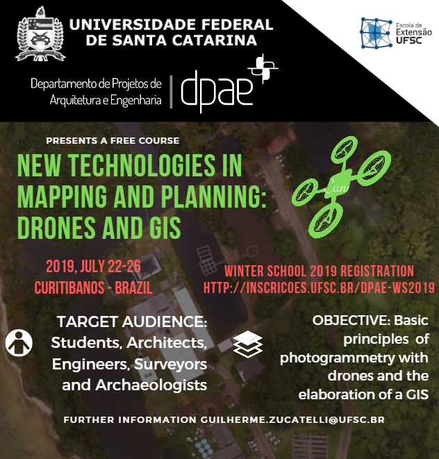
New Technologies in Mapping and Planning: Drones and GIS – 2nd Edition


The Department of Architecture and Engineering Projects – DPAE of the Federal University of Santa Catarina – UFSC, through the Extension School, is offering the second edition of the course New Technologies in Mapping and Planning: Drones and GIS at the University Campus in Curitibanos. The course will be held from 22th to 26th July 2019.
The course aims to teach the drones’ potentialities in the urban cadastre survey and the use of the geographic information system in urban planning with examples of the applicability on the Campus planning. Theoretical and practical classes will be taught at Campus Curitibanos facilities. As a result the student is expected to have notions of how to make photogrammetric products (orthophotomosaic, digital surface model, three-dimensional model) through the use of sensors embedded in drones and how to produce a geographic information system.
—
O Departamento de Projetos de Arquitetura e Engenharia – DPAE, através da Escola da Extensão, ministrará a segunda edição do curso Novas Tecnologias de mapeamento e planejamento: Drones e SIG no Campus da UFSC em Curitibanos a ser realizado entre os dias 22 e 26 de julho de 2019, em inglês.
O curso tem como objetivo ensinar as potencialidades dos drones no mapeamento urbano e o uso do sistema de informações geográficas no planejamento do Campus da UFSC. As aulas teóricas e práticas serão ministradas nas instalações do Campus Sede de Curitibanos. Como resultado, espera-se que o aluno tenha noções de como elaborar produtos fotogramétricos através do uso de sensores embutidos em drones e como produzir um sistema de informação geográfica.
—
Further information/ Saiba mais: http://dpae.seoma.ufsc.br/new-technologies-in-mapping-and-planning-drones-and-gis/
Registration/ Inscrições: http://inscricoes.ufsc.br/dpae-ws2019
Contact/ Contato: guilherme.zucatelli@ufsc.br
We invite everyone to participate!!//Convidamos todos a participarem!!!!